
The following flowchart shows the Symaptic Open Source Web and Mobile Package components and data flow. With the exception of Smallworld (proprietary software licensed by GE), all components are open source and are freely available for personal and/or commercial use (see Sympatic Component Licences for further information). The purpose and usage of each component identified in the diagram is further described below.
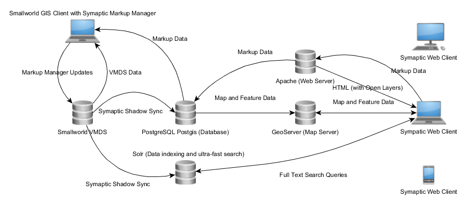
Symaptic Shadow
Geometry and attribute data is extracted from Smallworld into the PostgreSQL database using the Symaptic Shadow Plugin (a plugin written in Smallworld Magik). The plugin operates in either full or differential modes. Depending on the number of records, a full synchronisation of millions of records may take several hours, while differential synchronisations generally take a few of seconds.
PostgresSQL
PostgreSQL (or Postgres) is an object-relational database management system (ORDBMS) with an emphasis on extensibility and standards compliance. The Postgres extension PostGIS allows for the storage of spatial data. Both geometry and attribute data is extracted from Smallworld to Postgres using the Symaptic Shadow Plugin. Additionally, Postgres provides the short transaction capability for storing map markup information submitted from the Symaptic Web GIS Client via the Apache Web Server.
Solr
Solr (pronounced “solar”) is an open source enterprise search platform, written in Java, from the Apache Lucene project. Its major features include full-text search, hit highlighting, faceted search, real-time indexing, dynamic clustering, database integration, NoSQL features and rich document (e.g., Word, PDF) handling. The Symaptic Shadow module also passes record information to Solr. The records ares indexed, providing full text search capability of all data to the Symaptic Web GIS Client.
Geoserver Map Server
Geoserver is a OGC compliant implementation of a number of open standards such as Web Feature Service (WFS), Web Map Service (WMS), and Web Coverage Service (WCS). It provide a WMS and WFS service of the PostgreSQL data to the Geodrive Web Client for displaying geospatial and feature data.
Apache Web Server
Apache Web Server is secure, efficient and extensible server that provides HTTP services in sync with the current HTTP standards. It is the HTTP host host for the Symaptic Web GIS Client. Additional open source components such as PHP are by the Apache Web Server to provide functionality for map markup and other features.
Symaptic Web GIS Client
The Symaptic Web GIS Client is the web browser based client displaying the geospatial and attribute data from the Smallworld database. All records can be searched and displayed instantaneously, base maps of Google or Open Street Maps can be displayed, and Map Markups can be created and sent back to the Map Markup Plugin in Smallworld for processing. It using a number of open source web technologies such as Open Layers and JQuery.
Symaptic Markup Manager
The Symaptic Markup Manager is a Smallworld plugin allowing map markups created in the Symaptic Web GIS Client to be viewed and processed in Smallworld. Markup geometries can be converted into object geometries and comments and other textual information can be used to update feature attributes.